 |

Submitted by Graham, posted on 28 May 2001
|
 |

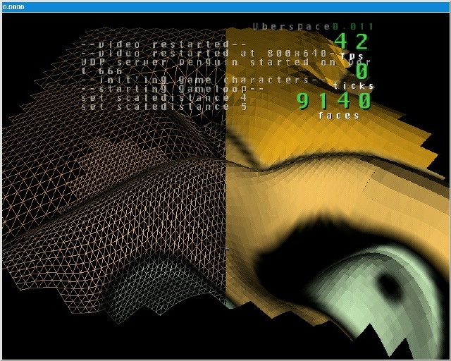
Image Description, by Graham

this is a screenshot from my game in development, which i [eventually]
intend to turn into a full game, ill just have to hire some others to do my
media (textures, modelling etc) anyways, onto the techy stuff
first the console, the heart of my game. the console consists of an output
and input (displayed in a dos console for servers and an on-screen display
for users and clients). when an input is proccesed, it splits up the char*
to match the command to a list in a hash table. commands are added with a
name and a function inside my code (yay function pointers) as are variables.
theyre either added beforehand as actual variables (pointers to
screenwidth/height etc). this great console allows me to test stuff quickly
and easily. oh and it loads cfg files too :]
next the terrain; (everyones doing it! <-- ive given in to peer pressure)
the whole map is tile based, with a grid of 4x4 heightmap per tile. when a
tile is drawn, it matches up the corners with the adjacent tile, so theres
no gaps(theres a bit on this at the end)
i load an image and get the average greyscale and set the height of that
particular tile's heightmap. rather than pre-determine the normals i work
them out on-the-fly as in the future the heightmap will be changed
(destructable :D)
as for drawing, ive recently switched to a new "scaledistance" (its a
varible in my console) so, (based on the viewdistance/culling distance and
the scaledistance) the further away the particular tile being drawn is, the
lower quality the tile (tiles per tile :) with just a level of 1,2 and 3.
this has helped me speed up the cfgs for lower range gfx cards :]
lastly, what i render, rather than a basic for(x=0) for(y=0) pair of loops,
i worked out a new method for what i should draw; i have a grid of bytes
(the same size as the amount of tiles existing on the map) and work out a
bounding rectangle of tile that should be drawn based on the viewdistance,
and less behind and to the side etc. then i just use a floodfill algorithm
to fill in the grid. this works a treat, saves a lot of cpu time, and is
very efficient :]
ive moved onto bringing in the networking stuff now (the site has a quick
mention on how to use it) and its going fine.
the *only* problems i have are that the method of the floodrender (as i call
it :) is that i cant to a total tri-strip render (its just per-tile atm).
Also when the scale changes, you can see gaps in the terrain as not as many
points match up (in-betweens of the heigtmaps on the tiles). my other
problem is my programmers art syndrome :]
anyone feedback is much appriciated and any solutions would also be cool.
the latest demo is avaible (and updates to the site) at www.uberspace.net :]
-- Graham at deadpenguin dot org
-- www.uberspace.net
-- www.deadpenguin.org
-- icq 13548542
|
|

